Geography
The Kingdom of Cambodia, formerly Kampuchea, is a Southeast Asian nation that borders Thailand, Laos, Vietnam, and the Gulf of Thailand. The capital city is Phnom Penh.
Geography
Situated in the southwest of the Indochinese peninsula, Cambodia occupies a total area of 181,035 square kilometers and borders Thailand to the west and northwest, Laos to the northeast, Vietnam to the east, and Gulf of Thailand to the southwest.
Cambodia’s geographic coordinates are 13 00 N, 105 00 E.
Cambodia’s terrain consists mainly of low plains, with mountains to the southwest and north.
Two dominant physical features of Cambodia are the Mekong river, which runs from north to south of the country, and the Tonlé Sap Lake.
Natural resources include oil and gas, timber, gemstones, iron ore, manganese, phosphates, hydropower potential.
Population
Cambodia’s population is approximately 14 million. Ninety per cent of residents are Khmer; the rest are Cham (Khmer Muslim), Chinese, Vietnamese, Indian, Thai, Phnorng, Kuoy, Stieng, Tamil, etc. Population density is 78/ km2.
Climate
Like most of Southeast Asia, Cambodia’s climate is hot and warm almost all year round. The climate is dominated by the annual monsoon cycle of rainy and dry seasons. The rainy season lasts from May to October, and the dry season from November to April. December to January are the coolest months, while the hottest period is in April. The average temperature is around 27-28ºC.
National Flag
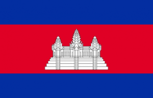 The flag of Cambodia symbolizes the country’s slogan: Nation, Religion, King. The two large blue stripes represent royalty and the center red stripe represents the nation. The image of the white temple stands for the nation’s religion.
National Flower
 The flag of Cambodia symbolizes the country’s slogan: Nation, Religion, King. The two large blue stripes represent royalty and the center red stripe represents the nation. The image of the white temple stands for the nation’s religion.